


Col La salette

JACQUES.FUMAT
User
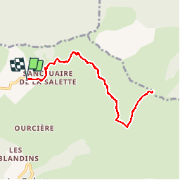

Length
9.2 km

Max alt
1983 m

Uphill gradient
369 m
Km-Effort
14.1 km

Min alt
1725 m

Downhill gradient
375 m
Boucle
Yes
Creation date :
2018-04-16 23:30:29.735
Updated on :
2018-04-16 23:30:29.735
3h07
Difficulty : Unknown

FREE GPS app for hiking
 SityTrail
IGN / Geographical institutes
SityTrail Plus
The world is yours!
About
Trail Walking of 9.2 km to be discovered at Auvergne-Rhône-Alpes, Isère, La Salette-Fallavaux. This trail is proposed by JACQUES.FUMAT.
Positioning
Country:
France
Region :
Auvergne-Rhône-Alpes
Department/Province :
Isère
Municipality :
La Salette-Fallavaux
Location:
Unknown
Start:(Dec)
Start:(UTM)
734971 ; 4971539 (31T) N.
Comments